


Entries By linden mallory
December 18, 2013
Posted by: Linden Mallory
Categories: Expedition Dispatches Aconcagua
Elevation: 16,600'
Once again clouds hungover Base Camp this morning and the moisture and cold temps covered camp in a thin layer of frost. We broke down camp and packed up our gear in the cold early morning shadows, stopping now and again to warm our hands while brushing frost off of the tents and packing them away.
The first rays of morning sunshine found us climbing out of Base Camp on our way to Camp 1. The rest and added acclimatization from yesterday paid off as we moved up the trail, making switchback after switchback up the rocky slope. By midday we reached Camp 1 and taking advantage of the good weather quickly set up our tents. Camp sits on a gentle slope at 16,600', just above a series of spires and cliff faces that roll off below us. The slope meant we had to put in some work rearranging rocks and flattening the platforms but before long we had everything set up and tied down in case the winds picked up.
The rest of the afternoon passed building rock walls for wind protection and retreating to the tents when occasional squalls of snow blew through. Thankfully nothing major came about and by early evening the clouds lifted a bit, giving us amazing views of the glaciers and peaks above Base Camp while we had dinner.
We're tucked into the tents and heading to bed to get some rest before tomorrow. Our plan is to make another carry to Camp 2, getting more supplies up there for when we move the following day. It's great to be out of Base Camp an up on the mountain. Tom and Thomas continue to climb very well and we are all adjusting to the altitude smoothly. Buenas noches from Campo Uno!
RMI Guide Linden Mallory
December 17, 2013
Posted by: Linden Mallory
Categories: Expedition Dispatches Aconcagua
Elevation: 14,400'
Today was everything you could ask for on a rest day during a mountaineering expedition: we stayed burrowed into our sleeping bags until the sun hit the tents at Base Camp and then enjoyed a leisurely breakfast, speculating about the outcome of the weekend's games that we missed and drawing out our meal well into the mid-morning. Taking advantage of the perfect weather, we spent a few hours spreading out our equipment and once again going through our gear, culling the unnecessary items and making sure that we had everything we needed for tomorrow's move to Camp 1. In the afternoon we wandered across the moraine to an old hotel built decades ago. Now boarded up, the stone and wood structure sits awkwardly in the middle of the landscape of rocks, glaciers, and snowfields. Despite its current state of neglect, it offers phenomenal views of Aconcagua's west side and while we stood there we were fortunate to have not a cloud in sight. By late afternoon the long shadows crept back over Base Camp and the temperature immediately began to fall as we wrapped up dinner. Base Camp's 14,400' elevation is starting to feel less challenging and we are feeling well rested and ready to move up the mountain. Tomorrow we will climb to Camp 1 at 16,600' and set up camp. While we've enjoyed being at Base Camp, we are ready to move onto the next portion of the climb, we'll check in tomorrow evening from higher up!
RMI Guide Linden Mallory
December 16, 2013
Posted by: Linden Mallory
Categories: Expedition Dispatches Aconcagua
Elevation: 16,600'
The clouds moved in after dinner last night and left a thin dusting of snow over camp. When I poked my head out of the tent early this morning things were looking ominous: a thick cloud cover hung just over camp and everything was white. But a few miles down the valley the cloud bank broke and I could see morning light hitting the peaks behind. Gradually as I watched the clouds overhead dissipated and the peaks immediately around Base Camp lit up in the pink morning light. With the hulk of Aconcagua immediately to our east, Base Camp sat in shadow while we crawled out of the tents for breakfast. Even by 8:30 with the clear skies and snow there was a nip to the air as we packed our bags but just as we shouldered our packs, the sun peaked over the ridge line high above and immediately warmed us up.
Bound for Camp 1 with loads of gear and supplies for the upper camps, we set out from Base Camp and crossed a small field of penitentes - the sharp snow spires - to begin ascending. The trail zigs and zags across the rocky scree slopes of Aconcagua, occasionally wrapping around rock outcroppings that jut out of the seemingly featureless slope. We made great time towards Camp 1, settling into a consistent pace and watching the brightly colored tents of Base Camp fade to small dots far below us. By midday we reached Camp 1, called "Camp Canada" which sits on the backside of massive stone tower at 16,600'. With the sun still shining and the winds holding at bay, we unloaded our gear and cached it among the snowdrifts and rocks at Camp 1. To our west large clouds were forming and soon after starting our descent the skies began to spit torrents of snow and hail that would come as quickly as they went. Between the snow flurries the sun would come out and it would be down right hot until the next wave of snow. Despite the swings in weather, and our constant clothing adjustments as a result, we made it back to Base Camp by mid-afternoon where we retreated to our tents to hang out and watch the clouds bounce over the mountaintops.
Tom and Thomas climbed remarkably well today, tackling the new terrain and altitudes with little fanfare and all the while keeping me entertained with unending stories. We are all feeling good after the day and looking forward to our planned rest day here in Base Camp tomorrow before we move higher on the mountain.
RMI Guide Linden Mallory
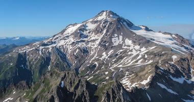
Buenas tardes from Plaza de Mulas, the Base Camp on Aconcagua's western side! Plaza de Mulas sits on a big rocky glacial moraine, near the eastern side of the amphitheater that makes up the head of the main Horocones Valley. Sharp summits surround us in every direction, the deep red color of the mountains here occasionally interested with striations of yellow and grey. Most of the peaks still hold snow from last winter snowpack and fields of penitentes - sharp snow spires that form from the intense sun - are emerging in the snow patches that still reside in the shallow gullies running alongside Base Camp. The panorama is framed by the massive cliff of glacial ice of Horocones Superior to our north and the hulk of Aconcagua rising immediately out of camp to our east. From this low on the mountain the majority of our route is obscured from view by the scree covered flanks running into camp, but far above us the steep cliffs that guard Aconcagua's twin northern and southern summits occasionally emerge from the clouds. Despite the relatively non-technical nature of this route, we still found ourselves craning our necks to look up at the mountain from Camp.
After reaching camp we quickly set up our tents and unloaded our gear that came in by mule. It was a relief to see that our gear made it unscathed after bouncing up the valley on the back of what seemed to be semi-tamed mules (whatever you do, don't stand in the trail and play chicken with an oncoming mule train!). With our camp established we explored around camp a bit before settling into our tents for some R&R right as the afternoon clouds spit a few sporadic snowflakes down on us.
The team is doing well and we are all very happy to be up high, finally eyeing the route above us and contemplating the next few days. If weather and acclimatization hold strong, we hope to carry a portion of our gear and supplies needed for the upper mountain to Camp 1 tomorrow. The sun is just starting to sink behind the ridge lines that separate us from Chile and the temperatures are getting chilly as we head off to dinner. We'll check in tomorrow after our day.
RMI Guide Linden Mallory
December 13, 2013
Posted by: Linden Mallory
Categories: Expedition Dispatches Aconcagua
Elevation: 10,000'


Finally with all of our gear, we left Mendoza this morning and headed for the mountains. The tree-lined streets of Mendoza gave away to carefully tended vineyards that produce the famed Malbec wine for which Mendoza is known. The road led into the foothills of the Andes, weaving along the edge of the thick red Mendoza River. The small hills soon grew to tall mountains and the road began passing through tunnels carved through the rock in the mountain sides. By midday we reached the ski outpost of Penitentes, a handful of kilometers from the Chilean border. Penitentes, no more than a few buildings with long slanted tat break the incessant winds, is a ski resort in the winter and a staging ground for Aconcagua climbers in the summer.
We spent the afternoon in Penitentes preparing our gear for the mountain. We set up and checked our tents, fired up the stoves, and packed our food and fuel into tight, well protected containers to endure the jostling of the mules on the approach to Base Camp. Once our loads were prepared, we ventured up the valley to Punta del Inca, a famous natural bridge created from geothermal springs that spans the entire river. Decades ago visitors would drive their cars across it. We ventured a bit further up the road to the mouth of the Horocones Valley where we caught our first views of Aconcagua since reaching Mendoza. Capped in clouds and new snow, the mountain's impressive south face loomed over the head of the Horocones Valley. It was an impressive, exciting, and humbling moment.
We are settled into our Hosteria now, enjoying the thin cold air, and happy to finally be in the mountains.
RMI Guide Linden Mallory
How come your going up the Mulas side as oppossed to the Vacas valley?
Posted by: Randy Christofferson on 12/14/2013 at 10:17 am

Reaching Mendoza, Argentina proved to be a tougher challenge than we anticipated for our team. Between cancelled flights, storm systems, and mechanical delays we all finally reached Mendoza, albeit a day late. Tom, Thomas and I happened to be on the same plane from Santiago to Mendoza and we had a stunning flight over the Andes with views north and south down the range. A fresh layer of snow blanketed the higher elevations of the mountains and Aconcagua stood tall above the surrounding peaks, it's summit trailing a thin cloud on its leeward side.
When we stepped off the plane in Mendoza the temperatures were 70F and sunny, the austral summer in full swing with green trees lining the tarmac - a striking difference from the cold temperatures that we left at home! Unfortunately, the relief about reaching Mendoza was quickly muted when Tom and Thomas' bags failed to appear. Undeterred, we filed our paperwork and were assured that the bags were on the next flight. So we headed into Mendoza, found our hotel, took a nice shower, and kicked back to share stories while we waited. And we waited, and we waited, and we waited...
The next morning found us back at the airport looking for a little more information on where the bags could have gone. The answer: Paris, France. It turns out that while we were hoping to head to Aconcagua's Canaleta, the bags had something more like the Champs Élysées in mind. Even in the days of barcodes and instant tracking, it still takes awhile for lost baggage to find it's way across three continents from Europe to the U.S. and finally Argentina. We made the most of the extra days in Mendoza to get the rest of our team gear organized, secure our climbing permits, catch up on rest from the flights, wander Mendoza's tree-lined streets, and enjoy a glass or two of Malbec while hanging out in some of Mendoza's outdoor cafes.
Finally by 5pm this evening the last of the missing bags reached Mendoza. We've enjoyed our time in town, but are eager to head to the mountains. Tomorrow morning we will make the drive into the Andes to the small outpost of Penitentes, wedged just south of Aconcagua National Park and a handful of miles from the Chilean border. We'll sort our gear there and spend a night or two acclimatizing before we head into Plaza de Mulas, Base Camp on Aconcagua's western Ruta Normal. We will check in tomorrow night from the mountains!
RMI Guide Linden Mallory
Coming off of a big climb or expedition often leads to the question, “What’s next?” The first priority is to take time to rest and recover. Any adventure in the mountains is a big physical and mental effort, and recovery time is valuable. Some light activity to stretch the legs can be a good idea but it's not always beneficial to jump back into intense workouts right away. In order to come back stronger, you need to recover first. Recovery time not only helps you physically recuperate but also gives you a mental break. When you do return to your training, you can do so with renewed motivation and excitement.
After a few good nights of sleep, take a moment to reflect on your past training and the climb itself: what worked in your training? What didn’t? What were you surprised about in the climb and how can you prepare better in the future? Take the extra minute to dig into this a bit, identify some key takeaways, and note these down.
For example, a few weeks after coming home with my tail between my legs from my first expedition to a remote peak in the Andes, I realized that while I felt aerobically strong throughout the climb, it took only a slight increase in pace or pack weight to send my exertion level through the roof. Additionally, the loose rocks of the lower mountain, fields of penitentes, and hard ice of the route were challenging to move across in a fluid manner, constantly testing my balance and ultimately wearing me out after a long day. In my training following the expedition, I focused on incorporating more interval training to increase my anaerobic threshold and to give me a larger aerobic capacity. I also incorporated more balance exercises into my gym routines, aimed at improving my ability to climb comfortably and efficiently despite the uncertainties of the terrain. On my next expedition, I was amazed at how much I gained by focusing on my weaknesses in my training.
With these area of focus noted, consider what you want to do next. If you’re eager to get back in the mountains, where do you want to go and what are the appropriate steps to get you there? Maybe it's to climb Mt. Rainier by way of another route? Are your sights set on 18,000’ or 19,000’ peaks like those in Mexico or Ecuador? Perhaps it’s the goal of climbing one of the Seven Summits like Aconcagua or McKinley?
After identifying your goal, do a little digging into what that climb looks like and what physical efforts are needed. What are the defining characteristics of the climb in terms of altitude, length, weight of pack, and technical skills? What kind of training do you need to focus on in order to tackle those challenges? Multi-week expeditions like Aconcagua or Denali require different preparation than a climb of several days like the North Cascades, Mexico, or Ecuador.
Take a look at your takeaways from your last climb and compare them with the challenges of your next climb. If it's a long expedition with heavy packs, maybe you need to build your aerobic strength and endurance to handle the extended exertion of the climb. If it's a shorter trip, perhaps it's improving your overall aerobic capacity while also increasing your strength and flexibility to meet the needs of the climb.
Completing these mental exercises helps bring your training path into focus. Continue to be strategic in your training, and it's not a bad idea to build benchmarks along the way to keep track of your progress.
Most of all, keep having fun. As climbers, it’s not just the summit day that generates the passion and excitement for us (although that’s often the most recognizable aspect to others), it’s the entire process of dreaming of a climb, working hard to plan and prepare for it, realizing it as you set foot on the mountain, and relishing in the memories afterwards.
________
Linden Mallory is a senior guide at RMI Expeditions.
Questions? Comments? Share your thoughts here on the RMI Blog!
June 2, 2013
Posted by: Linden Mallory, Walter Hailes
Categories: Expedition Dispatches Mount Rainier
Elevation: 11,200'

The Four Day Summit Climb led by Walter Hailes and the Five Day Summit Climb led by Linden Mallory reached Ingraham Flats (11,200') this morning before making the decision to turn the teams around due to unstable snow conditions.
The teams will descend from Camp Muir and return to Rainier BaseCamp in Ashford this afternoon.
We enjoyed a leisurely day in St. Petersburg on our last day in Russia. From our hotel we walked the several hundred yards to St. Isaac's Cathedral, climbing the 211 steps to the Colonnade that offers sweeping views of the city below. Built in the early 1700s, Peter the Great designed St. Petersburg after European cities and the city is often referred to as the "Venice of the North". Dozens of canals wind through the city, connecting to the Neva River running through the heart of St. Petersburg. From the Colonnade we could see over the rooftops of the city's early fortress, it's palaces and government buildings, and its beautifully restored churches.
Descending from the Colonnade we made our way to the Church of our Savior on Spilled Blood, an ornately decorated Church built over the stones where Tsar Alexander II was stabbed. Although built on a gloomy premise, the church's interior is incredible, with intricate, colorful mosaics covering the multistory interior. Lastly, we visited the Hermitage Museum, Russia's largest museum and home to over 4 million pieces of art. While the artwork matches any museum in the world, the building alone, built by Catherine the Great, is worth the visit in itself. Stretching out along the banks of the Neva, each room and hall is decorated in it's unique style.
After dinner (an excellent seafood restaurant) we climbed on board a boat and toured St. Petersburg's canals, winding through the buildings, under the roads and bridges, and along the Neva. Many of us leave early in the morning for flights home. It's been a great trip through Russia to Europe's highest peak, and we are looking forward to sharing the stories and photos with all of you at home.
RMI Guide Linden Mallory
We left the mountains this morning, piling all of our gear into the back of our van and following the small, twisting road out of the Baskan Valley and into the farmlands surrounding Mineralnye Vody. The fields of sunflowers were in full bloom and the day was clear enough that we could see Elbrus off in the distance.
Thanks to the upcoming winter Olympics in nearby Sochi they have recently finished renovating the Mineralnye Vody Airport and it was an easy process to get checked in, even with all of the excess baggage and climbing gear. Before long we were airborne, flying north across the country. We arrived in St. Petersburg in the early evening under grey skies, where the temps are far cooler than the planes to the south. We navigated the crowded streets of the city to find our hotel before heading out into the city for a nice dinner at a nearby cafe.
It's been a long day of traveling and we are happy to be here. St.Petersburg has a very different feel than Moscow and the Caucasus Mountains and we are looking forward to seeing the city. We are spending tomorrow, the last day of our trip, exploring St. Petersburg.
RMI Guide Linden Mallory
Previous Page
Next Page


Sounds breathtaking. Keep it up, glad the equipment arrived intact!
Posted by: Nanook on 12/16/2013 at 7:57 am
View All Comments