


Most Popular Entries


On The Map
Posted by: Mike Uchal, Adam Knoff, Zeb Blais
Categories: Expedition Dispatches Mt. McKinley
Elevation: 17,200'
RMI Guide Mike Uchal with the First Episode of As the Wind Blows
On The Map
Nelson-
You are an inspiration! I cannot wait to hear about your big adventure. I’m really proud of you. Take good care and I’ll see you later this year.
Katie
Posted by: Katie Taylor on 7/6/2012 at 2:49 pm
Nelson,
We just found out what your doing this summer! We are following you everyday!
Be safe and strong! We are anxious for clear weather! I wrote to James today to tell him what your up to. He completed Air Assault and has checked into Camp Buckner!
He is looking forward to visiting you at college this year! We loved seeing all your adventure photos from last summer and are so impressed to find out what your doing this summer! Not many people in the world can even attempt what you are doing! Glad to know you and be part of your life!
Thinking of you,
The Kinsey Family
Posted by: Lori Kinsey on 7/6/2012 at 2:30 pm
Posted by: Dustin Wittmier, Bailey Servais, Ben Thorneycroft
Categories: Expedition Dispatches Mount Rainier
Elevation: 11,200'

The American Lung Association Climb for Clean Air team was unable to reach the summit due to route conditions. The team climbed to Ingraham Flats to watch the sunrise before starting their descent. This team spends the year raising funds and supports the mission of the American Lung Association to saving lives by improving lung health and preventing lung disease.
Congratulations Team!

We got out of the tents at 6:30 this morning to find the clouds had returned. It was still calm though and not terribly cold at our 10,000 ft camp. We ate breakfast and hit the trail shortly after 8 AM. The trail was a good deal more rugged than yesterday’s with about a million rocky steps to negotiate as we steadily gained altitude through the giant heather forest. The morning rush hour was something to see, with porters from a half dozen expeditions charging up the path all at once. “Traffic” normalized after a few hours and the angle eased as we reached a ridge crest.
We found ourselves above the clouds once more as we moved along the ridge toward Kibo -which was not only visible again, but a good deal closer than it had been at our last glimpse. We made a big left turn to the North and began the traverse out toward Shira. The terrain got more interesting as we needed our hands on rock to pass a number of ledges. The vegetation changed as we closed in on 12,800 ft -our high point for the day- we saw more giant senecios and lobelias as things got higher and drier.
Finally, we turned the corner onto the Shira Plateau and began walking downhill toward camp. We pulled in at about 2 PM… just in time for lunch and an afternoon nap. By dinner at 12,500 ft, things had cooled considerably and many of us had several warm clothing layers on for stargazing before bed.
Best Regards,
RMI Guide Dave Hahn & Team
You’re getting there! Ella says “keep climbing Daddy (and Aunt Lynn and Uncle Peter)”!
Posted by: Sarah on 8/4/2022 at 3:10 am
Wishing you all a wonderful trip. So happy to be able to follow along. Enjoy! Charlotte-friend of Peter, Lynn and Steven’s
Posted by: Charlotte Multer on 8/3/2022 at 8:21 pm
Posted by: Mike King, Alex Halliday, Abby Westling
Categories: Expedition Dispatches Alaska Mt. McKinley
Elevation: 11,200'

Wednesday, June 2, 2021 - 5:24 pm PT
We had a cold clear night and woke to blue skies. The goal today was to cache food and fuel around Windy Corner at 13,500'. The route would take us up Motorcycle Hill and Squirrel Hill. From there it’s across the Polo Field and into the Saddle before Windy Corner. Windy Corner lived up to its name but the winner of the strongest winds today was the Polo Field. The Team did well and enjoyed the amazing views of the surrounding Alaska Range. We are back at 11K Camp eating food and enjoying some warm tents. We hope to move to 14K Camp tomorrow if the weather permits. There is a weather system forecasted that might keep us here for a few days. We’ll let you know when we know.
Great photos, looks spectacular. Stay strong Rob and team!
Posted by: Brett on 6/4/2021 at 7:07 am
Climb Strong Brother Tom!!!
Posted by: Dave Kestel on 6/4/2021 at 2:51 am
Posted by: Zeb Blais
Categories: North Cascades
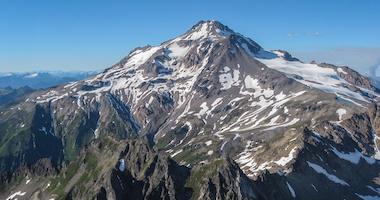
 While Sahale Mountain is a good introduction to the North Cascades, it is still a physically demanding climb that requires climbers to show up prepared. The approach is arduous. With heavy packs full of food, fuel, tents, climbing gear and layers, the thin climbers' trail winds through the forest about 3 miles and around 3,500' vertical up to the lowest camp in Boston Basin. One of our team counted crossing over 300 downed trees on the approach (he claimed to be accurate, but my hunch is that he cooked the books a little on that number). Regardless of the actual number, this wasn’t a well-maintained city sidewalk!
 Once we emerged from the thick forest, Boston Basin greeted us with spectacular views of granite peaks in all directions. North of camp Mount Torment and Forbidden Peak look as intimidating as their names imply. East of camp, Sharkfin, Boston Peak and Sahale fence in the Quien Sabe—Spanish for who knows—Glacier. Simply camping in this setting is worth the price of admission, but at this point the fun was just beginning.
 After setting up camp, we rested for the remainder of the day to get an early start on a day of training for our summit bid. Much of the climbing on Sahale consists of moderate rock, so our team focused on rock movement for much of our training day. Between camp and the Quien Sabe Glacier lies 1,400' of low and moderate angle granite slab walking. Moving on this terrain requires skillful footwork and good balance. After practicing smearing, edging and route finding on rock we gained the glacier. Donning crampons, harnesses and ice axes we delved into efficient movement techniques for snow, ice and glacial travel. With our team's improved movement skills, we headed back to camp ready to tackle our objective the next day.
 We rose early, in full darkness, to set ourselves up for a potentially long summit push. Due to light snow accumulations over the winter and a hot summer, the Quien Sabe had very little seasonal snow remaining. The route wound from the far north edge of the glacier to the south where the glacier bumps up against a rock arrete at 8,200'. The climbing was straightforward and there was only one section of glacier where we needed to walk with absolute focus on each step.
At the south end of the glacier, we moved onto rock for about 50' vertical feet and then climbed directly up a steep snow face. We had watched teams navigating the bergshrund (the largest, highest crevasse on a glacier) just north of this area the previous day while we were training. We decided the jumbled ice plugs and snow bridges they had crossed were not something we wanted to tangle with unnecessarily, and we believed that we had spotted a smoother route to the South that eliminated the hazard of walking through broken ice of the "direct" route.
Above the bergshrund, we found smooth climbing onto the ridge. Often a moat can form between the glacier and the rock, which can make the transition from glacier to rock difficult, but this wasn’t the case for us. A small step off the glacier onto the solid rock of Sahale's summit ridge was all it took. 50' of 3rd class scrambling put us on the ridge headed for the summit pyramid.
We rose early, in full darkness, to set ourselves up for a potentially long summit push. Due to light snow accumulations over the winter and a hot summer, the Quien Sabe had very little seasonal snow remaining. The route wound from the far north edge of the glacier to the south where the glacier bumps up against a rock arrete at 8,200'. The climbing was straightforward and there was only one section of glacier where we needed to walk with absolute focus on each step.
At the south end of the glacier, we moved onto rock for about 50' vertical feet and then climbed directly up a steep snow face. We had watched teams navigating the bergshrund (the largest, highest crevasse on a glacier) just north of this area the previous day while we were training. We decided the jumbled ice plugs and snow bridges they had crossed were not something we wanted to tangle with unnecessarily, and we believed that we had spotted a smoother route to the South that eliminated the hazard of walking through broken ice of the "direct" route.
Above the bergshrund, we found smooth climbing onto the ridge. Often a moat can form between the glacier and the rock, which can make the transition from glacier to rock difficult, but this wasn’t the case for us. A small step off the glacier onto the solid rock of Sahale's summit ridge was all it took. 50' of 3rd class scrambling put us on the ridge headed for the summit pyramid.
 Robby and I short roped our teams along the narrow rocky ridge until we arrived at the last steep pitch leading to Sahale's pointy summit. This pitch presents a 4th or low 5th class move or two to get to the highest block of granite on top. We pitched out this section, running our rope out to the top and belaying our climbers up the short step. What a great way to top out! Without a breath of wind on the summit, our team enjoyed the high perch for a full half hour before starting the descent.
 Our team moved well across the softened the surface of the glacier, and soon we were back on the rock slabs above camp stripping crampons. We just had a couple of short stretches of slab to down climb to get back to our tents. The team pulled it off in great style and we finished the climb telling stories and watching a beautiful sunset.
With gravity and the motivation of a meal in town helping us, we descended the climbers’ trail back to our cars. Soon we were enjoying cold beer and Marblemount's best barbecue, Que Car BBQ!
Whether you've done a pile of 14ers or this is your first mountaineering trip, Sahale is a great trip.
_____
Our team moved well across the softened the surface of the glacier, and soon we were back on the rock slabs above camp stripping crampons. We just had a couple of short stretches of slab to down climb to get back to our tents. The team pulled it off in great style and we finished the climb telling stories and watching a beautiful sunset.
With gravity and the motivation of a meal in town helping us, we descended the climbers’ trail back to our cars. Soon we were enjoying cold beer and Marblemount's best barbecue, Que Car BBQ!
Whether you've done a pile of 14ers or this is your first mountaineering trip, Sahale is a great trip.
_____Zeb Blais is a senior guide at RMI Expeditions. He has climbed and skied mountains across the globe. In the spring of 2014, he set out to traverse Tajikistan's Fedchenko Glacier on skis. Find Zeb on Instagram at @zebblais.


Jason, Lance, and Andy, you guys were great!
Thank you!
Posted by: Shawn B. on 7/19/2013 at 9:59 am
Sandy, You are a beast! Congrats!
Posted by: Jackie & Dan on 7/11/2013 at 1:36 pm

You all are looking good and healthy. Stay healthy and strong for your summit. Looking forward to reading about it. Blessings for a safe summit.
AQ Uptown#985 NM/AZ/CO
Posted by: Rachael C. Lujan on 5/15/2013 at 10:17 am
Love the beard buddy. Looks like your having the time of your life. Good luck everyone at work and myself are rooting for you. Be Safe! Look forward to your return and your stories.
Larry
Posted by: Larry Price on 5/15/2013 at 7:49 am


After a shorter day the team headed from Paine Grande into the French Valley. Clouds and wind set the tone for what would be a partially sunny day where the clouds stayed high above. The glaciated Paine Grande massif dominates the valley to the left. Then as you get up higher, the largest of the alpine cirque comes into view with granite towers and walls everywhere you look. The remaining trail to Refugio Los Cuernos goes along a massive turquoise lake and is situated under the Cuernos (Horns) rock formation. Tomorrow we’ll be back in the Central area for the night and a hike to the Torres Wednesday morning concludes our trek.
New Post Alerts:
Torres del Paine Trek, February 3, 2024
Posted by: Dave Hahn, Seth Waterfall
Categories: Expedition Dispatches Vinson Massif
Elevation: 9,300'

On The Map
Bruce,
I clicked on the link for the page here and they had a link for Mt. Kili. More my speed. Best of luck on the climb up tomorrow. If you see penguins on the way back remember to stuff one into your pack for me. I don’t expect you to lug one all the way to the top. Everyone at GFH3 says hi.
Posted by: Reid on 12/9/2012 at 6:13 pm
Sterling. I’m back in OC. Guess this is a rest day? Incredible pictures!! Hoping for continued good weather. Sue
Posted by: Sue on 12/9/2012 at 2:36 pm


Hey ya Guy! Hope you’re having fun climbing mountains all the days! Stay safe and take pics for Bub!!
Posted by: Sharon Waters on 2/12/2017 at 9:09 am
View All Comments